WASHINGTON – The map that defines the way many Washington-area residents think of their neighborhoods and commutes needs a new look.
With the Silver Line set to open by the end of the year, Metro is out with a final draft of the new rail map and is looking for feedback on one last decision.
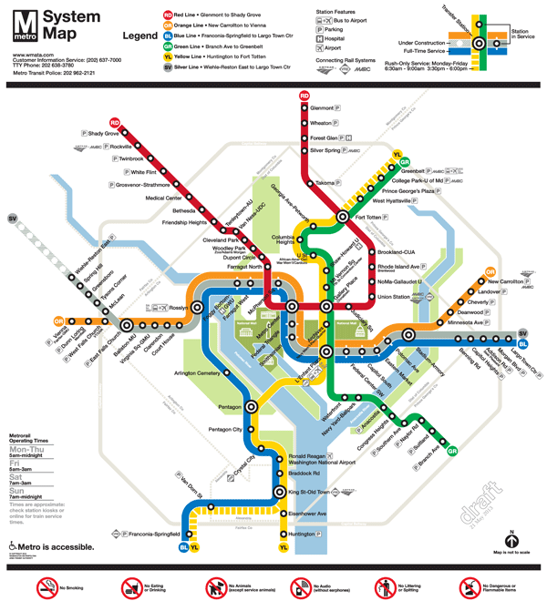
The two final options for the Metrorail map have thinner rail lines, changes that make the Silver Line stand out more than previous drafts, and new green space east of the Anacostia River to represent Anacostia National Park.
Another change based on feedback from earlier drafts moves the Silver Line between the Orange and Blue lines for the stretch of rail between Rosslyn and Stadium-Armory.
It is that stretch, where Metro will have three different lines sharing the same tracks for the first time, that constitutes the focus of the final request for public feedback.
While transfer stations will still be marked with a symbol that looks like a target, the stations between Rosslyn and Stadium-Armory will either be marked by the current station dot with thin white lines extending into the Orange and Blue lines to show that they stop at that station as well, or by the current station dot stretched into an oval that connects all three lines.
Compared to the current map, the biggest change riders will notice is the addition of the Silver Line and its Phase 1 stations, including McLean, Tysons Corner, Greensboro, Spring Hill and Wiehle-Reston East.
The Silver Line will run from Wiehle-Reston East Station to Largo Town Center when it first opens, following the Orange Line tracks between East Falls Church and Rosslyn and then the current Blue Line route.
“Rush Plus” service remains on the new maps for the Yellow Line. Some trains departing from Franconia-Springfield during rush hour will no longer have a spot in the tunnel from Rosslyn to D.C., so they will be redirected over the Yellow Line bridge toward Greenbelt.
Here are the two map appearance options that Metro is considering:

You can tell Metro which option you like best here. The new map options are designed by Lance Wyman, the same man who designed the original Metro map.
Follow @WTOP on Twitter.