WASHINGTON – In the aftermath of superstorm Sandy, the National Weather Service has a flood warning in effect through Thursday evening for parts of the Potomac River.
The flood warning until covers the Potomac River at Harpers Ferry, at Point of Rocks and near Little Falls. The warnings for those areas are in effect until Thursday afternoon or evening.
The coastal flood warnings for the Potomac River in D.C., Prince George’s County, Fairfax, Falls Church and Alexandria will be in effect until 2 p.m. Friday. A coastal flood warning means flooding is occurring or imminent and that property owners should take appropriate action to protect themselves and their property.
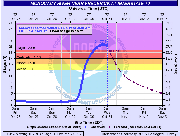
The National Weather Service early Wednesday reported that major flooding occurred along the Monocacy River in Frederick County.
At 2 a.m. the Monocacy was at 21.4 feet, more than 6 feet above flood stage. Flood stage for the river is 15 feet.
At 20 feet, the National Weather Service says the water reaches Gambrill Mill on the Monocacy National Battlefield.
The flooding at Monocacy could be the worst since Hurricane Agnes in 1972.
Wednesday morning’s crest compares to a previous crest of 18.1 feet on Dec. 27, 2009.
By mid-afternoon, the river level will fall below flood stage. Here are the river levels along area rivers.
At 7 a.m., the Potomac River was at 15.1 feet at Harpers Ferry. Flood stage is at 18 feet. The river was cresting at that hour.
At Point of Rocks, flood stage is 16 feet, and the river was at 18 feet at 7 a.m. The river is not expected to fall to below flood stage until mid-afternoon Thursday. Moderate flooding is expected.
Near Little Falls, the Potomac River was at flood stage — 10 feet — at 7 a.m. The river is expected to keep rising to 10.7 feet by early evening. At 11 a.m. water will cover the towpath of the C&O Canal.
The crest is not expected at Little Falls until Thursday evening, the weather service says.
The upper tidal Potomac is running 3 feet above normal.
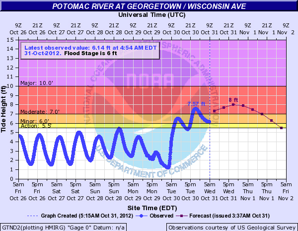
As the waters flow down the Potomac, the worst conditions are expected in Georgetown Wednesday into early Thursday. High tide Wednesday at Georgetown will be at 10:13 a.m. Wednesday and 10:19 p.m. Wednesday.
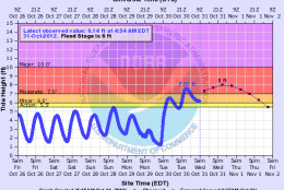
Flood stage is 6 feet along the Potomac, and the river is expected to crest at 8.6 feet at the Wisconsin Avenue river gauge in Georgetown by early Thursday morning, according to National Oceanic and Atmospheric Administration flood forecasts.
Major flooding occurs if the river reaches 10 feet at the Wisconsin gauge and forecasts say it is possible the river will hit that mark. That would bring water levels up to K Street in Georgetown. If waters rise even higher, the floods would reach Independence Avenue, SW and 17th Street, NOAA forecasts say.
So far, the low-lying monuments and memorials along the National Mall have come through the storm unscathed, according to National Park Service spokeswoman Carol Johnson.
The World War II Memorial, Johnson says is the most vulnerable to some possible minor flooding, but is designed to withstand flooding and would not be damaged.
Johnson says the Mall’s flood-protection system can protect it from crests of 17 feet or higher.
Meanwhile portions of Old Town Alexandria Tuesday night were closed to traffic as the waters of the swollen Potomac River overflowed its banks.
The water lapped passed South Union Street as the high tide came in about 10 p.m. Tuesday but began receding again soon after.
Businesses along and near King Street weren’t taking any chances and sandbagged doors and windows to guard against the flood waters, which are expected to creep even higher during Wednesday’s high tide at 10:06 a.m.
Follow WTOP on Twitter.
(Copyright 2012 by WTOP. All Rights Reserved.)